
DONNER LAKE RIM TRAIL
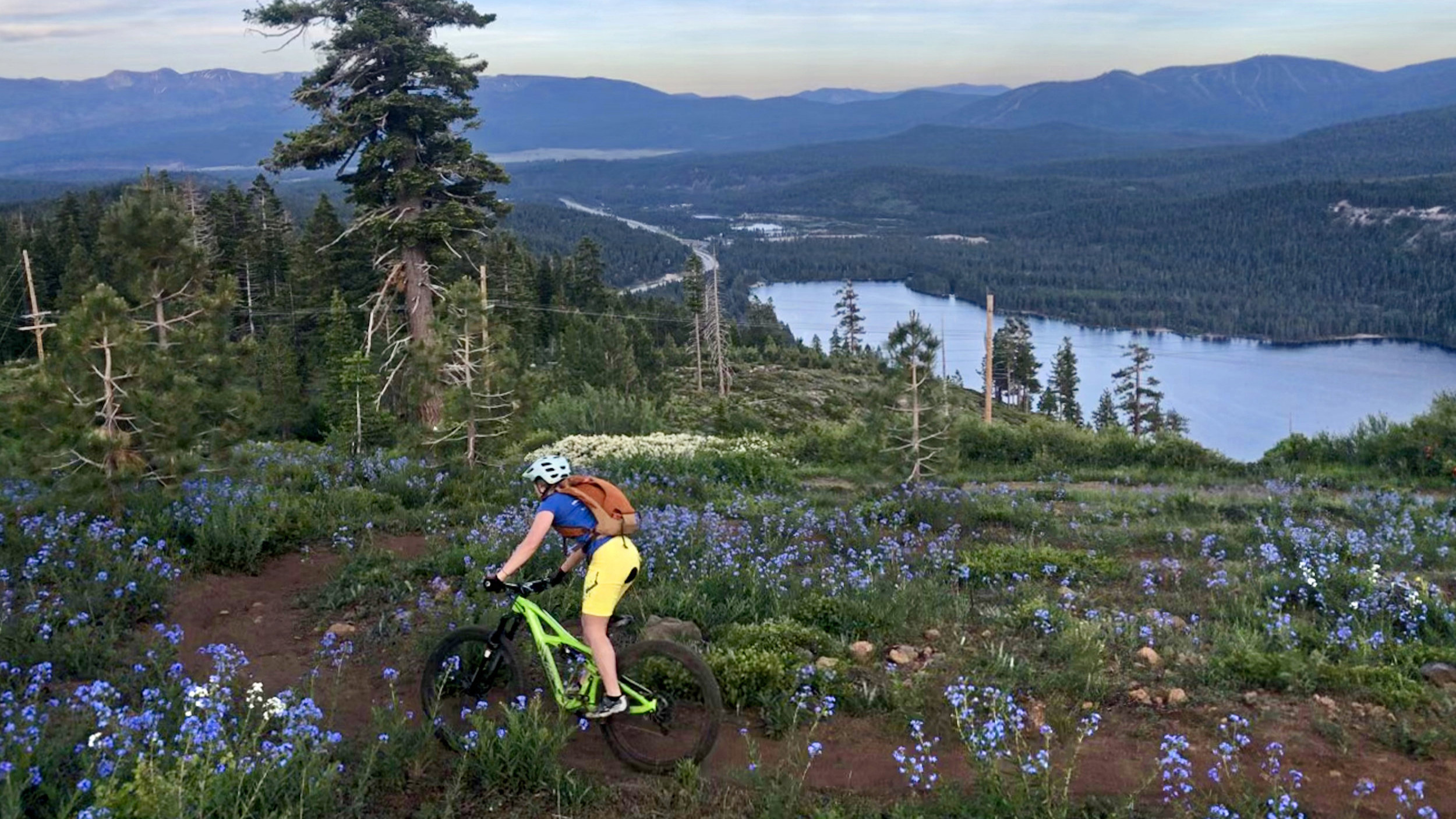
The Donner Lake Rim Trail (DRLT) is a Land Trust project to build a 23-mile multi-use trail on the mountains and ridges surrounding Donner Lake. Hikers, mountain bikers and equestrians will enjoy stunning views of Donner Lake, Mount Rose and the Pacific Crest. Trails will run from downtown Truckee to Donner Summit and connect with existing trails, including the Pacific Crest Trail (PCT), Warren Lake Trail, Summit Lake Trail, the Hole-in-the-Ground Trail, and the trails leading into the proposed Castle Peak Wilderness. Currently 12 miles of the 23-mile trail have been constructed and are available for public use.
Video of Katerina Nash riding the Donner Lake Rim Trail by Džefík Productions.
Most of this 12-mile segment was built by the Land Trust and volunteers and with the help of other partners such as the US Forest Service, Tahoe Donner, the Truckee Trails Foundation, California State Parks and the California Conservation Corps.
Using the Donner Lake Rim Trail with the main access trails, which are described below, and other existing trail systems, enterprising hikers, mountain bikers and equestrians can construct outings of a variety of lengths and difficulty.
Smartphone navigation
field notes
EAST TO WEST ROUTE DESCRIPTION
The Donner Lake Rim Trail (DLRT) starts on Northwoods Boulevard, across the street from the Trout Creek paved trail that connects to downtown Truckee. From the Trout Creek trail parking area, walk directly across Northwoods Boulevard and onto a dirt road with fences on both sides. Continue up the dirt road for about 100 yards to a fork. The left fork is marked with a small Donner Lake Rim Trail sign on a post. Take the left fork onto the DLRT, leaving the dirt road and continue uphill. You are now on the new 4-mile long section stretches west below Skislope Way in Tahoe Donner, passing through mixed conifer forest, massive granite boulders and open vistas with views of Donner Lake and the Sierra Crest. Trending uphill as it goes west, the trail eventually reaches the Land Trust’s picnic table at the Johnson Canyon Overlook, where visitors can either connect back into Tahoe Donner at Glacier Way, or continue west on the Donner Lake Rim Trail
From the Picnic Table, the trail heads in a northerly direction up a ridge. After about 0.9 miles several Tahoe Donner trails enter from the right. At the last of these intersections the DLRT goes left as indicated by a sign. If you were to continue straight you would get to the Drifter Hut which is part of Tahoe Donner’s cross-country ski area.
This begins a 700 foot descent down Johnson Canyon through a series of gentle switchbacks. There are seasonal wildflowers, open forest and thick colonies of tall Braken Fern in this part of the canyon. At the bottom is the intersection of the DLRT with the Wendin Way access trail described below. The DLRT/Wendin Way intersection is marked by two metal, Yosemite style trail signs.
At the DLRT/Wendin Way intersection, the DLRT goes right and immediately comes to the first of three bridges. After crossing the bridge you ascend to a service road. Turn left on the service road and in 1/3 of a mile, turn right onto the DLRT where it leaves the service road. After this, the DLRT gradually ascends, crossing two more bridges until you come to an intersection with the ATV road that comes up Johnson Canyon. The DLRT goes right on the ATV road and follows it towards Summit Lake. Before you get to the lake, there is a fork in the road. The DLRT goes right, up the hill. Five miles from the start of the DLRT, the trail arrives at Summit Lake.
After enjoying the view of Summit Lake, continue on about a half-mile to the intersection with the Warren Lake Trail which is marked by a wooden sign on the north side of the trail. The section of trail between this intersection and Summit Lake is one of the most popular hikes in the area. Mountain bikers should be prepared to encounter a number of hikers is this half mile section, especially on summer weekends. Please be especially courteous to one another – hikers please make it easy for bikers to pass and bikers please let hikers and other bikers know of your approach well ahead of time and slow down as you pass them.
At the intersection with the Warren Lake trail, the Summit Lake trail goes left and connects with the PCT. The Warren Lake Trail goes right and the DLRT goes straight. About a mile from this intersection you arrive at a flat area just before the trail ascends through a rocky “staircase” to the highest point since the descent into Johnson Canyon. This flat area has great views of the Pacific Crest and the nearby ski areas. It has lots of smooth, granite rocks for sitting making it a nice rest stop. Ascend from here up the rocks to the high point and 0.6 miles beyond the high point you intersect a dirt road. The DLRT turns left, following the road, and after a short distance, intersects the PCT.
Hikers, can go left at the intersection of the PCT. That route will take them to a PCT trailhead on the south side of Interstate 80 at the Boreal exit.
From the intersection with the PCT, the DLRT continues straight on the ATV road, which turns in a more southerly direction, crosses a stream and enters Castle Valley Meadow. After a short uphill, the DLRT meets the Castle Valley Road Trail (a dirt ATV road). You will have gone ½ mile since the single-track intersected the dirt road. Going left on the Castle Valley Road Trail brings you to the trailhead near the Boreal off-ramp on the north side of Interstate 80 in a half mile. Going right on Castle Valley Road takes you to the Hole-in-the-Ground trailhead and the trail to Castle Peak.
Currently 12 miles of the 23-mile trail have been constructed and are available for public use.
ACCESS
The completed portion of the Donner Lake Rim Trail can be accessed from several places. The DLRT is marked with blue and white emblem trail markers. If you are not familiar with the areas described be sure to consult a detailed area map, and/or a person well acquainted with the described areas.
Johnson Canyon: Exit I-80 at the Donner Lake Interchange about half way between Truckee and Donner Summit, or take Donner Lake Road from the west end of Donner Lake. A dirt road leaves the interchange on the north side of I-80 and quickly takes you to a large dirt parking area on the right side of the road. The new access trail, called Wendin Way, begins in the parking lot, to the left of the kiosks. While at the kiosks note the rules and regulation for the Wendin Way section of trail. Also note the list of donors and partners that helped make this access trail and the Donner Lake Rim trail possible.
The elevation there is approximately 6,500 feet. After a little less than one mile, the access trail intersects with the Donner Lake Rim Trail. Proceed to the west (left) to Summit Lake, or to the east (right) to Tahoe Donner.
Tahoe Donner: Access the Donner Lake Rim Trail from Tahoe Donner’s Glacier Way trailhead. Follow the Tahoe Donner trail system to the Johnson Canyon Overlook. There are a number of trails intersecting the trail you want which goes straight until you reach a sign directing you left to the Johnson Canyon Overlook and the Donner Lake Rim Trail. Just beyond the picnic table there’s a post with a Donner Lake Rim Trail emblem marking the beginning of the DLRT.
Note that the Glacier Way Access Trail is on Tahoe Donner property and subject to their Access, Safety and Usage Rules which are posted on the trailhead kiosk and on the Tahoe Donner website.
Northwoods Boulevard: Head up Northwoods Boulevard toward Tahoe Donner, then turn toward the Trout Creek Trailhead on the right to park, just after Lamplighter Way. Cross back over Northwoods Boulevard to find the DLRT trailhead.
I-80 at the Summit: Access the Donner Lake Rim Trail via the Summit Lake – Warren Lake trail starting at the Pacific Crest Trail trailhead on the south side of the Boreal exit. On the right side of the kiosk is a map of the DLRT and a list of donors and partners. Reminder, the Pacific Crest Trail is closed to wheeled traffic, including bicycles.
Castle Valley Road (hiking, equestrian, and bicycle access at Donner Summit): Exit the I-80 and proceed to the north side of the freeway. The road (unsigned) that starts on the north side of the freeway is Castle Valley Road. Proceed up Castle Valley Road to a green Forest Service gate and park where space is available. The elevation at this point is about 7,300 feet. Proceed north on Castle Valley Road a half mile from the kiosk, until reaching a prominent fork, which is signed with a Donner Lake Rim Trail blaze mounted onto a post. To continue on the DLRT, turn right at the fork and follow this double-track for about ½ mile. The single-track begins on the right side of this road, and is also signed.
RULES, REGULATIONS, GOOD TO KNOW
Please observe the rules posted on the kiosks at the access trailheads
No open fires
Pack out your pet’s waste
Pack out all trash
Do not harass wildlife or allow your pet to harass wildlife
Bicyclers yield to equestrians and hikers. Hikers yield to equestrians
Please be courteous to all the users of the Donner Lake Rim Trail. Keep the spirit of Howdy!